
14 Photos BEFORE and AFTER which Show How the Earth Has Changed
In recent years, NASA has been keeping track on the major transformations that have taken place on the Earth. The agency publishes before and after photos; the differences are often breathtaking.
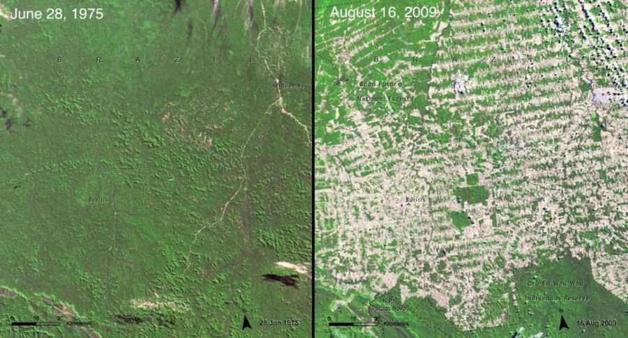
1. Rainforests have been devoured up by farms in Brazil
The image above shows the state of Rondônia in western Brazil, one of the most deforested parts of the Amazon. In 1978, 2% of the rainforests in the state were chopped down. By 2008, it was up to 34%—an area the size of West Virginia. New roads stick out in the forests like fishbones, as the nearby trees disappear soon after.


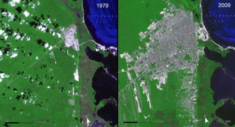
2. Cancun has been expanding at a galloping speed
The images above show the rapid growth of Cancun, Mexico. In the 1970s, this area was sparsely populated, home to artisanal fishermen and empty beaches. But the government insisted on turning the area into a tourist hotspot and today it is home to 722,000 people.
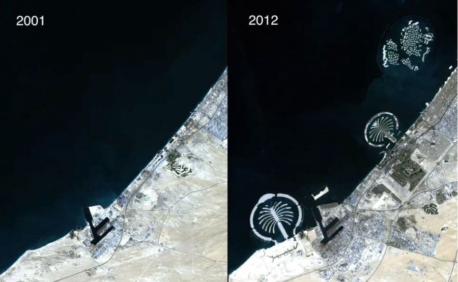
3. Dubaj is building a chain of artificial islands
The photo shows the rapid growth of Dubai, UAE. To encourage beach tourism, the city built hundreds of artificial islands along the coast using sand taken from the seashore. Rocky barriers were placed to protect them from erosion. The two most famous islands are shaped like palm trees.
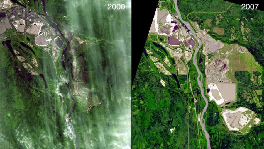
4. The oil sands boom in Alberta, Canada
The images above show the growth of oil sands production near the Athabasca River in the 2000s. After the sand is mined, it is rinsed with hot water to separate the bitumen. The sand and water are then discharged into tailings ponds, which can be seen as smooth brown squares in the images. Those mines have had a profound impact on the landscape around them. Forests should be cleared to make way for the mines - more than 256 square miles as of 2011.
5. The landscape of Ukraine is recovering after Chernobyl
The images above show the development of the area around the Chernobyl nuclear power plant after the reactor explosion in 1986. On the left you can see the area in 1986, just before the incident. There are tilled fields, small towns and old forests. Then on 26 April, radiation began leaking from reactor number four at Chernobyl and people left the area.

Since 2011, things have looked completely different. Abandoned cities are crumbling down. Farms have now turned into pastures. The forests were cut down by the government and replanted. Interestingly, plant and animal populations actually have increased in the restricted area after the incident. The animals are still adversely affected by the radiation, but they also thrive in the absence of humans.
6. Artificial fire is ravaging Namibia
Forest fires were a crucial part of the ecosystem. Before humans came along, Namibia's savannahs burned about once a decade. When Etosha park managers put out these sporadic wildfires, it only led to really massive fires later when the vegetation piled up.
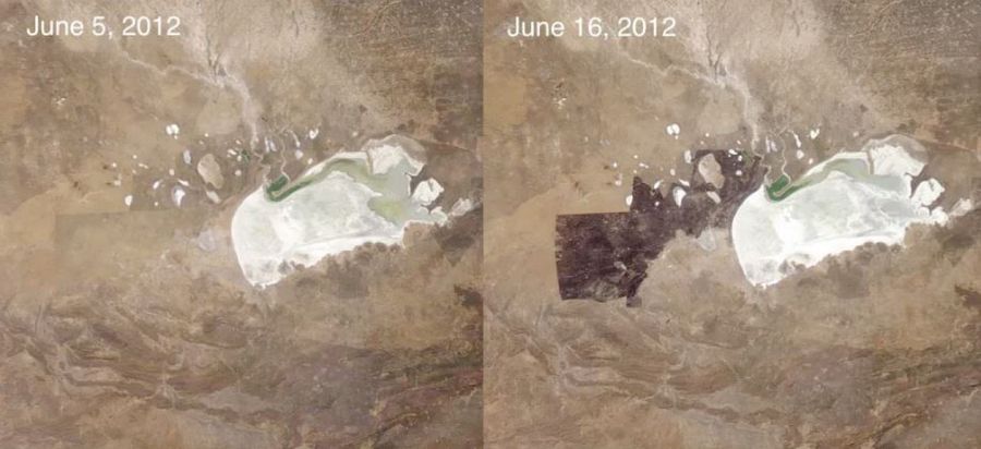
Now in Namibia, park managers periodically try to start smaller fires themselves. Sometimes, however, these fires can get out of control, as happened in June 2012, shown in the satellite image above. On 9 and 10 June, winds picked up and the fire quickly spread westward. Fortunately, no animals were harmed - unlike an out-of-control fire in 2011 that killed 30 rhinos.
7. Attempts to tame the Colorado River hit a snag
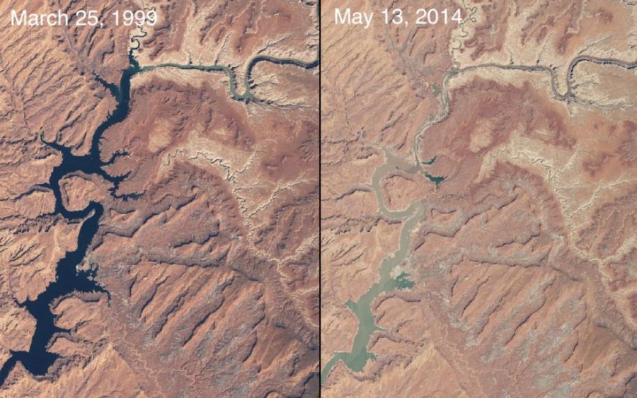
The Colorado River flows out from the Rocky Mountains and goes through the American Southwest. In the 20th century, Americans built an elaborate system of dams and reservoirs to tame the river, providing a constant source of fresh water for farms and cities like Phoenix and Las Vegas. However, nature cannot be controlled completely. The images above show Lake Powell, a pond on the border of Arizona and Utah that was created after the construction of Glen Canyon Dam. In 1999 the lake was full with plenty of water for nearby counties. However, in the early 2000s, a severe drought hit and water levels began to drop. As of May 2014, the capacity of the lake was only 42 percent.
8. The Aral Sea
The Aral Sea- located between Kazakhstan and Uzbekistan, was once the fourth largest lake in the world. Today, after decades of being drained for irrigation, it is almost gone.

9. The Columbia Glacier in Alaska is shrinking rapidly
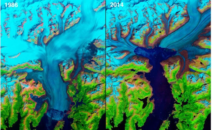
One of the most dramatic ways we have been transforming the planet is through global warming. A great place to see its effects is through the melting of glaciers and ice sheets around the world. The images above show the Columbia Glacier in Alaska flowing directly into the sea. The glacier remained more or less intact from its discovery in 1794 to 1980, then suddenly it began to shrink. From 1986 to 2014, its head retreated 12 miles to the north, making it one of the fastest shrinking glaciers in the world.
10. The Larsen B Glacier in the Antarctic is crumbling down
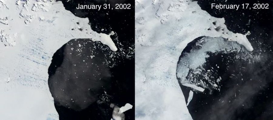
Melting ocean glaciers will raise sea levels. Scientists witnessed a dramatic example of this in 2002, when a huge chunk of Larsen B ice shelf in the Antarctic—an area of 1 250 square miles—simply crumbled into the ocean within a month.
11. USA cleans out the air pollution
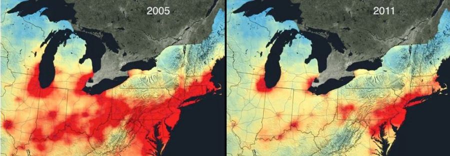
Satellite data from NASA, shown above, reveals a huge reduction in nitrogen dioxide pollution from cars, trucks and power plants in the United States from 2005 to 2011.
12. The marshes of Iraq have been recovering after Saddam Hussein
In the 20th century, the lush wetlands in Iraq between the Tigris and Euphrates rivers dried up, mostly due to a series of dams that were built for electricity, as well as Saddam Hussein's deliberate strategy to drain the wetlands and punish the Arabs from the marshes in the region for an uprising. As the images above show, things have changed significantly since the Second Gulf War. After the fall of Saddam Hussein, the Iraqis closed many of the canals that had drained out the marshes.

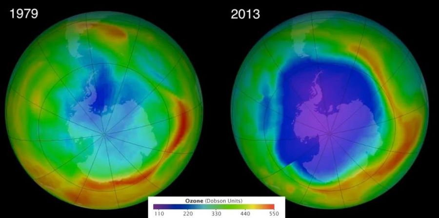
13. The ozone layer is getting thinner, then it starts healing up
Back in the 1970s, scientists first realized that we were rapidly depleting the stratospheric ozone layer of the Earth, which protects us from the harmful ultraviolet rays of the sun. This was because of the presence of chlorofluorocarbons, which are mainly used in refrigerators and air conditioners. Fortunately, that apocalyptic scenario never happened. Scientists discovered the problem in time. Pursuant to the Montreal Protocol of 1987, world leaders agreed to phase out freon and eventually the hole in the ozone layer stopped expanding.
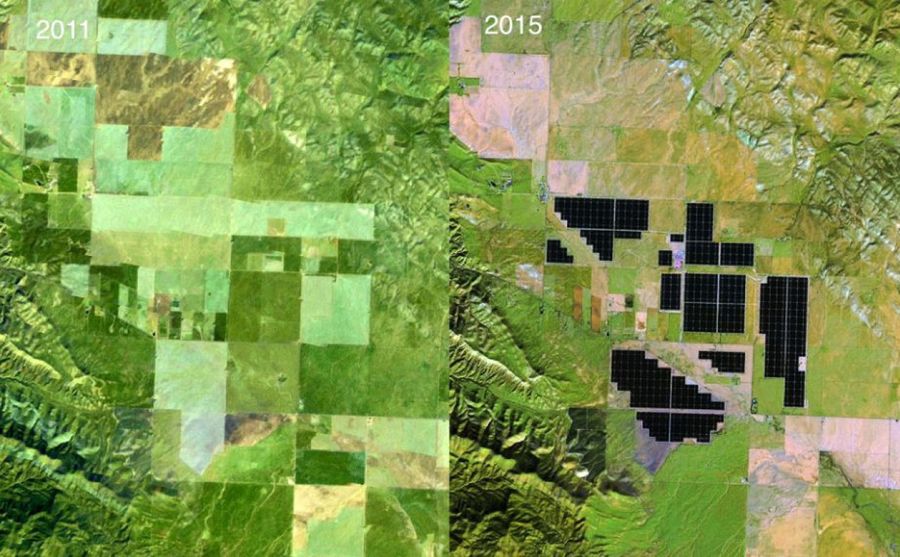
14. Solar farms are popping up in California
The next big environmental challenge is global warming, which is likely to prove much more difficult to stop than the ozone layer. This will bring a restructuring process of our entire energy system; divestment of fossil fuels such as coal, oil and natural gas; and search for cleaner resources. Some places are already taking steps in this direction. The image above shows the growth of the Topaz Solar Farm in central California, a 550-megawatt plant consisting of 9 million panels over 9.5 square miles. It is a modest step in moving the state toward cleaner energy.
Source: vbox7.com